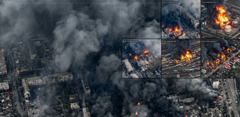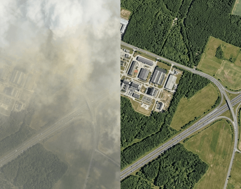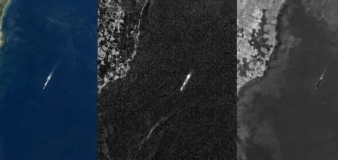

Modern Intelligence, Surveillance, and Reconnaissance (ISR) defense architectures no longer depend on a single satellite payload. While individual imaging modalities offer distinct spatial, spectral, or temporal advantages, operating them in isolation creates critical intelligence gaps. A single visual pass can be rendered useless by sudden overcast skies, while a synthetic radar pass may spot a metallic structure without revealing whether it is an operational missile launcher or a hollow decoy.
To achieve persistent, uncompromised domain awareness, defense procurement teams, systems integrators, and mission planners are turning to multi-sensor fusion. By combining Short-Wave Infrared (SWIR), Electro-Optical (EO), and Synthetic Aperture Radar (SAR), Earth observation networks deliver uninterrupted, multi-layered threat detection that operates effectively across all atmospheric conditions and operational theaters.
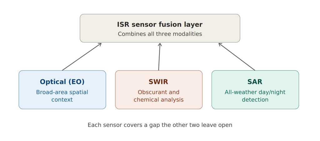
The ISR sensor fusion layer: optical, SWIR, and SAR combined for continuous coverage
1. Evaluating Individual Sensor Modalities
Selecting the right combination of ISR satellite sensors requires a clear understanding of what each wavelength band reveals and where it fails.
Electro-Optical (EO) Sensors
Electro-Optical imagery serves as the primary visual baseline for tactical mapping, spatial reconnaissance, and broad-area surveillance. Operating primarily within the visible (0.4 μm – 0.7 μm) spectrum, these passive sensors record reflected sunlight to reproduce scenes exactly as human eyes see them.
Key strengths
- High spatial detail: Achieves industry-leading spatial resolution (frequently sub-50cm, down to 30cm commercial limits), making it ideal for micro-level structural assessment, vehicle identifying features, and runway damage verification.
- Intuitive imagery: Requires minimal post-processing for human intelligence analysts, speeding up manual verification during time-sensitive command decisions.
- Broad constellation ecosystem: Enjoys widespread commercial availability, lowering data acquisition costs for routine, broad-area mapping.
Critical limitations
- Zero night capabilities: Completely dependent on natural solar illumination, leaving large operational blind spots during night missions.
- Weather vulnerability: Easily blocked by cloud coverage, dense sea fog, low-altitude overcast, and heavy atmospheric dust.
- Susceptible to deception: Highly vulnerable to standard visual camouflage nets, structural paint patterns, and inexpensive physical decoys designed to mimic legitimate targets visually.
Short-Wave Infrared (SWIR) Sensors
Operating between 1.0 μm and 3.0 μm, SWIR fills the critical spectral gap between visible light and thermal infrared radiation. Unlike thermal sensors that measure emitted heat, SWIR relies on reflected photons that interact directly with the molecular bonds of physical objects.
Key strengths
- Atmospheric penetration: Passes directly through battlefield smoke, heavy atmospheric haze, industrial dust, and burning particulate matter via Mie scattering physics.
- Chemical and material fingerprinting: Distinguishes natural vegetation from artificial military netting, revealing painted decoys and identifying specific metal compositions.
- High-temperature signature detection: Captures intense thermal contrast events, making it exceptional for detecting active rocket motor burns, missile exhaust plumes, and immediate post-strike combustion.
Critical limitations
- Coarser spatial detail: Typically operates at lower spatial resolutions (often 4m to 8m GSD) compared to ultra-high-resolution visible sensors.
- Thick cloud blockage: While superior at cutting through smoke and haze, SWIR cannot penetrate dense, liquid-water cloud layers.
- Higher hardware costs: Specialized focal plane arrays (often utilizing Indium Gallium Arsenide / InGaAs or Mercury Cadmium Telluride / MCT materials) increase payload procurement expenses.
Synthetic Aperture Radar (SAR)
Synthetic Aperture Radar is an active microwave sensing technology operating in the 1 cm – 30 cm range (typically X, C, or L bands). Because SAR emits its own radar pulses and measures the backscattered return signal, it does not rely on sunlight or optical clarity.
Key strengths
- All-weather 24/7 operations: Functions continuously through total darkness, storm clouds, dense fog, hurricane rain bands, and heavy smoke.
- Structural geometry and texture sensing: Measures surface roughness, metallic dielectric constants, and geometric structures, making metal hulls and infrastructure stand out clearly.
- Micro-deformation tracking: Coherent phase tracking (InSAR) detects ground movement, surface subsidence, and vehicle tracks down to millimeter-scale changes.
Critical limitations
- Complex data interpretation: Produces speckle noise, layover, and foreshortening effects that require advanced algorithmic processing or specialized imagery analysis.
- High power requirements: Demands substantial SWaP-C (Size, Weight, Power, and Cost) overhead from the satellite bus to power microwave transmissions.
- No spectral data: Incapable of evaluating spectral properties, such as plant health, water chemistry, or painted material absorption.
2. Head-to-Head ISR Payload Comparison
When evaluating payload specifications for mission integration, trade-offs between spatial clarity, weather dependency, and material identification determine sensor placement within an ISR constellation.
| Capability / Specification | Electro-Optical (EO) | Short-Wave Infrared (SWIR) | Synthetic Aperture Radar (SAR) |
| Primary wavelength range | 0.4 μm – 0.7 μm | 1.0 μm – 3.0 μm | 1 cm – 30 cm (X, C, L-band) |
| Day / night operation | Day only | Day / limited thermal hotspots | 24/7 day and night |
| Cloud and fog penetration | No | Limited (haze / thin fog only) | Full penetration |
| Smoke and haze penetration | Minimal | High (Mie scattering) | Full penetration |
| Camouflage detection | Poor | Exceptional (chemical absorption) | Moderate (coherence / structure) |
| Ideal primary role | High-res visual identification | Material and obscurant validation | All-weather tipping and cueing |
3. Practical Use Cases for ISR Sensor Fusion
Fusing SWIR, Optical, and SAR data streams converts raw data into actionable tactical intelligence, neutralizing individual sensor limitations.
Maritime Domain Awareness
Detecting uncooperative or “dark” targets in open ocean environments requires multi-tiered payload coordination.
Tipping and cueing workflows
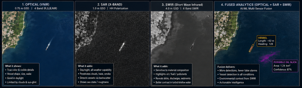
- Wide-area search (SAR): Wide-swath SAR constellations scan thousands of square kilometers of open ocean in a single pass. Because calm water absorbs radar signals and appears dark, metallic ship hulls and wake patterns reflect high backscatter energy, triggering immediate detection alerts regardless of weather or darkness.
- Precision target identification (SWIR/EO): Automated systems immediately cue low-latency SWIR and Optical payloads to the exact SAR coordinates. As the cued optical satellite passes over, SWIR cuts through humid coastal haze to capture sharp vessel reflections, confirming ship classification, registration features, and deck cargo.
Tracking dark vessels
Illicit vessels disabling their Automatic Identification System (AIS) transponders often hide beneath heavy cloud cover or operate inside foggy littoral channels. SAR pins down ship movements, while SWIR instantly distinguishes valid metallic hulls from false surface anomalies or decoy barges, providing verified maritime intelligence to naval command.
Defense and Tactical Reconnaissance
In complex terrestrial environments, multi-spectral sensor fusion defeats optical camouflage, smoke screens, and deceptive decoys.
Piercing smoke screens and obscurants
During active combat operations, artillery fire, burning oil, and tactical smoke screens obscure visual satellite sensors. Because SWIR wavelengths are larger than smoke particulate sizes, light passes through the cloud unobstructed. Commanders track armored unit maneuvers and perform immediate Battle Damage Assessment (BDA) without waiting for battlefield dust to clear.
Camouflage and decoy suppression
In modern warfare, rubber decoys and painted wooden frames mimic expensive air defense systems or tanks to exhaust adversary munitions. Optical sensors alone can be fooled by precise physical paint matches. However, SWIR sensors measure light absorption profiles; synthetic paints reflect SWIR differently than real armor steel or military-grade anti-reflective coatings. Concurrently, SAR measures structural density to confirm target authenticity, eliminating expensive target confusion.
Border and Perimeter Security
Land borders and critical facility perimeters present a persistent monitoring challenge: long, remote stretches of terrain where illicit crossings, smuggling routes, and tunneling activity are easy to miss with a single sensor type, especially at night or in poor visibility.
Detecting illicit crossings and subsurface activity
- Wide-area perimeter watch (SAR): InSAR coherence change detection flags freshly disturbed soil, vehicle tracks, and ground subsidence consistent with tunneling, even under cloud cover or at night, cueing analysts to zones warranting closer inspection.
- Nighttime movement detection (SWIR): SWIR captures reflected moonlight and artificial illumination far better than EO in low-light conditions, revealing vehicle convoys, foot traffic, and staging areas that would otherwise go undetected between daytime passes.
- Positive identification (EO): Once SAR and SWIR cue a location of interest, high-resolution EO imagery confirms whether the activity is legitimate agricultural or civilian traffic versus an unauthorized crossing, minimizing false escalations.
Critical Infrastructure Monitoring
Pipelines, power generation facilities, ports, and communications infrastructure require continuous structural and security monitoring across vast, often inaccessible areas, where a missed anomaly can mean undetected sabotage, theft, or a costly unplanned outage.
Structural health and intrusion detection
- Millimeter-scale deformation tracking (SAR): InSAR phase coherence detects subtle ground and structural shifts around pipelines, dams, and substations weeks or months before visible damage appears, enabling predictive maintenance rather than reactive repair.
- Material and thermal anomaly detection (SWIR): SWIR identifies chemical leaks, overheating transformers, and unauthorized excavation near buried assets by detecting material and thermal signatures invisible to the naked eye.
- Visual verification and site mapping (EO): High-resolution EO imagery documents perimeter fencing, access roads, and physical security posture, supporting both routine compliance audits and rapid post-incident assessment.
Disaster Response and Wildfire Monitoring
Natural disasters most often strike under exactly the conditions that defeat single-sensor ISR: heavy cloud cover, smoke, and darkness. Sensor fusion keeps situational awareness flowing when responders need it most.
Hotspot detection and damage assessment through obscurants
- Active fire front tracking (SWIR): SWIR penetrates smoke plumes to pinpoint active burn fronts and residual hotspots, giving incident commanders an accurate, continuously updated fire perimeter even as smoke obscures the visible spectrum.
- All-weather flood and damage mapping (SAR): SAR maps flood extent and structural collapse through the storm systems that typically accompany major disasters, when EO satellites are grounded by cloud cover for days at a time.
- Pre- and post-event comparison (EO): Once skies clear, high-resolution EO imagery provides the detailed before-and-after comparison needed for damage assessment, insurance claims, and rebuilding prioritization.
4. The SWIRSAT Operational Framework
The LatConnect 60 (LC60) SWIRSAT constellation demonstrates how modern satellite fleets operationalize multi-sensor ISR fusion.
High-fidelity native resolution
SWIRSAT combines multispectral SWIR capabilities alongside high-resolution visible channels. By overlaying detailed visible spatial baselines with specialized short-wave infrared bands, the payload ensures that material composition and chemical absorption data map directly onto fine structural features.
Edge-AI onboard processing
To minimize time-sensitive defense intelligence delays, SWIRSAT integrates onboard Space Edge Computing architecture. By processing multi-spectral imagery directly in orbit, the system runs target extraction algorithms at the moment of capture, shrinking telemetry latency down to actionable tactical alerts sent directly to field commanders.
Resilient sovereign constellations
By building a multi-sensor intelligence layer, LC60 provides sovereign defense forces and intelligence agencies with dedicated, high-frequency access to tactical ISR insights. This multi-layered monitoring secures land borders, protects critical maritime routes, and delivers verified intelligence regardless of atmospheric conditions or deceptive tactics on the ground.