Satellite Intelligence for National Food Security.
LC60 partners with national agriculture agencies and government-linked corporations to deliver crop monitoring, yield forecasting, and digital agronomy at population scale — from policy desks to the smallholder farm.
Built for the missions that matter.
Five operational capabilities — each enabled by sovereign SWIR observation.
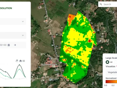
Built for National Scale
National agricultural agencies need the ability to monitor millions of hectares, support hundreds of thousands of smallholder farmers, and deliver insights in local language on entry-level devices.
LC60 has supported a national rice and grain agency with farm management infrastructure across more than 125,000 smallholder farmers, and is scaling toward national programmes covering over one million producers.
WHAT WE DELIVER
Farm Management Platform
Web-based dashboards for agency staff to monitor crop yield, performance, and operational metrics across entire farming populations.
Satellite-Derived Crop Analytics
Weekly and biweekly field-level analytics using NDVI, NDRE, NDMI, and MSAVI indices to track crop health and uniformity.
Yield Forecasting
AI-driven harvest prediction supporting national food security planning, procurement, and policy decisions.

Wide-Area Mapping Capability
Beyond farm-level intelligence, LC60 has delivered wide-area data capture, analytics, and delivery for state government mapping programmes covering more than 900,000 square kilometres.
Common questions
AG60 is built for population-scale agriculture. We work with national agriculture ministries, government-linked corporations, and large agribusinesses that need consistent visibility across entire production regions — from policy dashboards for ministry analysts down to advisories for individual smallholder farms. The same platform supports a few thousand hectares or several million.
AG60 supports the major staple and commercial crops grown across the Asia Pacific — including rice (irrigated, rainfed, and lowland), oil palm, rubber, sugarcane, maize, soybean, and horticultural crops. New crop models are added on a programme basis when a ministry or grower group commits to a deployment.
Forecasting accuracy depends on the crop, the maturity of in-country calibration, and the density of ground-truth observations available. For mature programmes with established calibration, AG60 typically targets crop-area accuracy within a few percent and yield forecasts that converge with end-of-season government statistics. We deliver every forecast with confidence intervals so analysts can see the underlying uncertainty rather than a single number.
Yes — this is core to the design. AG60 fuses optical, radar (SAR), and SWIR observations so that cloud cover during monsoon and wet-season periods does not blind the platform. SAR sees through cloud day or night; SWIR adds soil moisture and crop stress signal that optical alone misses.
Yes. Farmer onboarding can be done by extension officers using shared tablets in the field, with farm boundaries digitised once and re-used. Advisories are delivered through whatever channel the farmer actually uses — SMS, voice notes, or in-person via extension visits. AG60 is designed around extension networks, not assumptions about device penetration.
AG60 delivers data via standard formats (GeoTIFF, STAC, CSV, REST API) so that crop maps, yield estimates, and risk alerts can be ingested directly into ministry GIS, statistics, and policy systems. We also provide LC60-hosted dashboards for analysts who do not have a GIS team.
For national agriculture programmes, the customer owns the data. LC60 can operate inside customer infrastructure or under a data sovereignty agreement that keeps all national-level data within the country’s borders. This is non-negotiable for ministry deployments and is reflected in our standard contracts.