A Complete Guide to Short-Wave Infrared and How SWIRSAT Uses It From Space
If you have ever wondered why some cameras can see through smoke, haze, or camouflage when a normal photo can’t, the answer is usually SWIR. Short-Wave Infrared is a part of the light spectrum that is invisible to the human eye but incredibly useful for revealing what standard imaging misses. It has quietly powered industries from mining to firefighting for decades, and it is now becoming one of the more important tools in satellite-based Earth observation.
This guide covers what SWIR actually is, how it works at a physical level, where it is already used across different industries, and how LC60 is bringing it to orbit through SWIRSAT, a satellite capability designed to make SWIR imagery available globally, repeatedly, and at a resolution useful for real decision-making.
What Is Short-Wave Infrared (SWIR)?
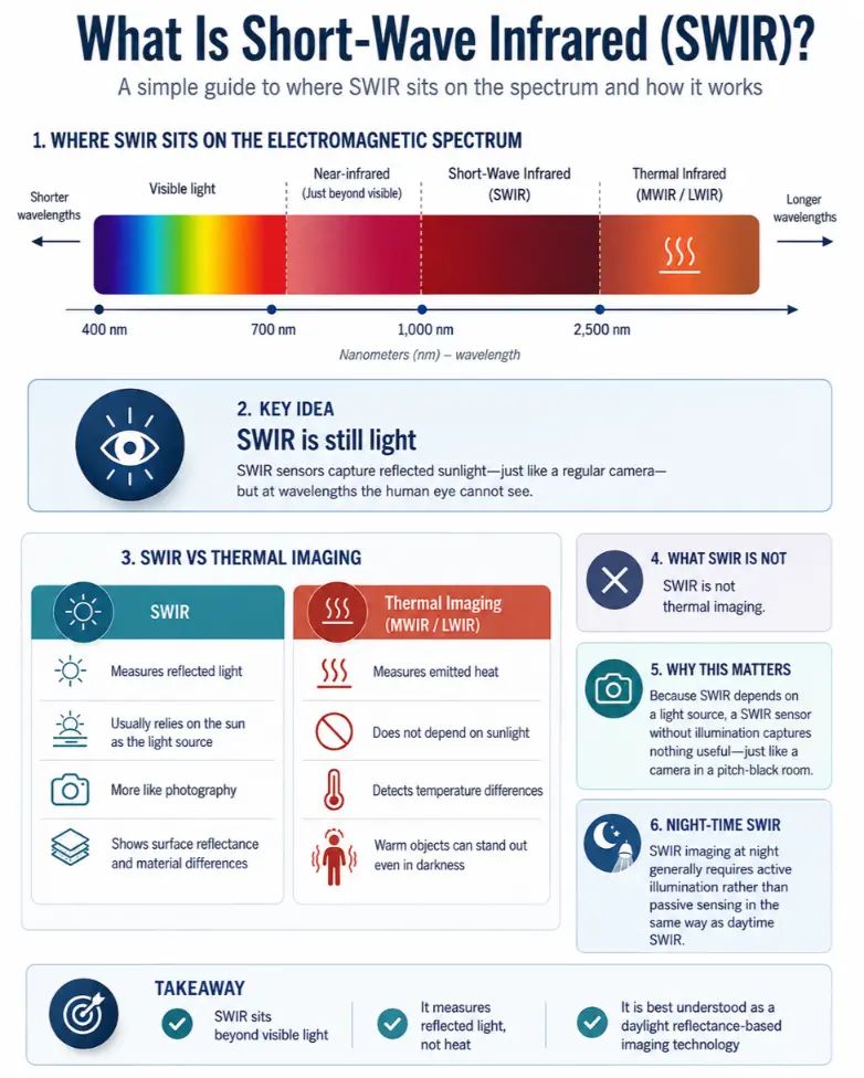
SWIR sits on the electromagnetic spectrum just beyond the light we can see. Visible light runs from roughly 400 to 700 nanometers, violet at the short end, red at the long end. Just past red sits near-infrared, and beyond that, generally spanning 1,000 to 2,500 nanometers, is short-wave infrared.
Despite the name, SWIR is still, technically, light. This is the detail most people get wrong. A SWIR sensor captures reflected sunlight, the same basic principle as a regular camera, just tuned to wavelengths our eyes were never built to detect. That single distinction is the key to understanding everything else about SWIR.
It is not thermal imaging. Thermal cameras, often labelled MWIR (mid-wave infrared) or LWIR (long-wave infrared), detect heat that objects emit on their own, which is why a thermal image shows a warm body glowing regardless of how dark or bright the surroundings are. SWIR does the opposite. It needs a light source, typically the sun, and it measures what bounces back off a surface. That makes SWIR a daylight, reflectance-based technology, closer in principle to photography than to heat detection, even though it operates in a part of the spectrum most people associate with “infrared.”
This is worth restating clearly, because it shapes what SWIR can and cannot do: a SWIR sensor without a light source captures nothing useful, in the same way a camera in a pitch-black room captures nothing useful. SWIR imaging systems that operate at night generally do so with an active illumination source, not by passively sensing in the way daytime SWIR systems do.
How SWIR “Sees” What Other Sensors Can’t
Every material interacts with light differently depending on wavelength. Two surfaces that look identical to the naked eye, and to a normal camera, can look completely different under SWIR because of how their molecular structure absorbs and reflects those specific wavelengths.
Material Discrimination
Water molecules absorb strongly at certain SWIR wavelengths, which means moisture content, whether in soil, vegetation, or building materials, shows up clearly as a distinct signature. This is why SWIR can often tell the difference between:
- Dry soil and recently disturbed or moist soil
- Natural vegetation and synthetic materials made to look like vegetation, such as camouflage netting
- Different rock and mineral types that appear visually identical
- Genuine structures and decoys built from different underlying materials
None of this requires the object to look different to a human eye. It only requires the object’s material composition to interact differently with SWIR wavelengths, which is a far more reliable signal than colour or shape alone.
Atmospheric Physics: Why SWIR Cuts Through Haze
The reason SWIR performs better than visible light in hazy, smoky, or humid conditions comes down to a phenomenon called Rayleigh scattering. Rayleigh scattering describes how light bounces off tiny particles in the atmosphere, and its strength depends heavily on wavelength: shorter wavelengths scatter far more than longer ones. It is the same reason the sky looks blue. Blue light has a short wavelength and scatters in every direction across the atmosphere, while longer wavelengths pass through more directly.
SWIR sits at a considerably longer wavelength than visible light, which means it scatters far less when passing through haze, thin smoke, dust, and humid coastal air. It is not immune to atmospheric interference. Thick, dense smoke or heavy cloud cover will still degrade a SWIR image. But across the moderate obscuration that routinely blinds a standard optical sensor, that is, everyday haze, dawn and dusk atmospheric conditions, coastal humidity, and light-to-moderate smoke, SWIR consistently holds up where visible-light cameras lose usable detail.
Common Applications of SWIR Technology
SWIR has been used across industries for years, well before satellites carried it into orbit. Some of the most established applications include:
● Agriculture. Farmers and agronomists use SWIR to measure soil moisture and plant water content, which supports irrigation planning and early identification of crop water stress, often before visible symptoms like wilting appear.
● Mining and geology. SWIR is a standard tool in mineral exploration. Different rock and mineral types have distinct reflectance signatures in the SWIR range, which geologists use to map likely ore bodies and rock formations without physically sampling every location.
● Industrial inspection and quality control. Moisture content in manufactured goods, food products, and construction materials can be measured non-destructively using SWIR. Recycling facilities also use SWIR sensors on sorting lines to distinguish between plastic types that look identical to the eye but have different chemical compositions.
● Semiconductor inspection. Silicon is transparent to certain short-wave infrared wavelengths, which makes SWIR imaging useful in electronics manufacturing and failure analysis for inspecting internal structures without physically opening a component.
● Firefighting and emergency response. SWIR can map fire behaviour and burn areas through smoke that would blind a standard camera, giving incident commanders a clearer picture of where a fire actually is, not just where the smoke plume suggests it might be.
● Security and defense. Camouflage and concealment techniques are generally designed to fool the human eye and standard optical sensors. Because SWIR responds to material composition rather than visual appearance, it is far harder to deceive with paint, netting, or visual decoys alone.
● Night vision equipment. Ground and airborne SWIR imaging systems, typically paired with an active illumination source, are widely used in security and defense applications for low-light conditions. This is a different mode of operation from the passive, daylight SWIR sensing described earlier in this guide.
● Art conservation. Conservators and museums use infrared and short-wave infrared imaging to see beneath paint layers, revealing underdrawings, earlier compositions, and material changes invisible under normal gallery lighting.
Historically, most of this capability has come from aircraft, drones, or handheld and fixed ground sensors. Getting the same underlying physics from orbit, at global scale and on a repeatable schedule, has been the harder engineering problem. That is the gap SWIRSAT is built to close.
Introducing SWIRSAT: Space-Based SWIR From LC60
SWIRSAT is LC60’s satellite-based SWIR imaging capability, purpose-built to bring this technology to orbit and make it available as a repeatable, global data source rather than a one-off aircraft sortie or a single ground survey. SWIRSAT pairs dedicated SWIR sensing with high-resolution VNIR (visible and near-infrared) imagery on the same platform, so every capture combines the sharp structural detail of a conventional satellite image with the material and moisture insight that only SWIR can provide.
Rather than treating SWIR as a niche or experimental sensor, SWIRSAT was designed around a specific gap: conventional optical satellites are blinded by haze and smoke, and while radar (SAR) can see through cloud entirely, it struggles to tell one material from another. SWIR sits in the space between them, adding a layer of confirmation and discrimination that neither optical nor radar alone can provide.
The Four SWIR Bands, and What Each One Is For
SWIRSAT operates across four dedicated SWIR spectral bands, each selected for a specific physical interaction with materials on the ground, rather than as a generic broad-spectrum capture:
Band 1, 1,270nm. This band is sensitive to vegetation water content and sits within an early atmospheric window. It supports vegetation stress detection, canopy condition monitoring, and early indicators of concealment where natural vegetation has been disturbed or replaced.
Band 2, 1,364nm. This wavelength sits within a strong water-absorption region of the spectrum, making it sensitive to soil and surface moisture. It is the primary band for detecting ground disturbance, such as recent excavation, vehicle movement, or construction activity, since disturbed soil holds and reflects moisture differently than undisturbed ground, often for weeks after the activity itself has stopped.
Band 3, 1,570nm. This band responds to mineral and material composition, with reduced atmospheric scatter compared to shorter wavelengths. It supports material discrimination between natural and artificial surfaces, which is central to identifying camouflage, disguised structures, and man-made objects placed to resemble natural terrain.
Band 4, 1,649nm. This is the optimal window for smoke penetration. It is the band most relevant to post-event assessment, whether that is a wildfire, an industrial incident, or another event that leaves smoke or residual particulate obscuring the ground.
Each band is co-registered with SWIRSAT’s VNIR imagery, meaning the SWIR data and the high-resolution optical data are captured over the same location at the same time and aligned pixel-for-pixel. This gives analysts a single, coherent dataset rather than two separate images that need to be manually reconciled.
SWIRSAT Technical Specifications at a Glance
● Four dedicated SWIR bands: 1,270nm, 1,364nm, 1,570nm, and 1,649nm
● 4m Super HD SWIR resolution, co-registered with 1.5m VNIR resolution
● 11km swath width at nadir
● 4 to 7 day global revisit, with daily revisit available in priority regions, improving toward daily global coverage as additional satellites join the constellation
● Daylight, sun-reflectance operation. Like all passive SWIR systems, SWIRSAT relies on reflected sunlight and does not collect usable imagery at night
● On-orbit AI processing to reduce the time between capture and usable insight
Why Resolution and Revisit Are a Trade-Off, Not Just a Spec Sheet
It is worth explaining why these specific numbers matter, rather than presenting them as marketing figures. At 4m resolution, an individual vehicle is generally resolvable in a SWIRSAT image, but reliably classifying exactly what that vehicle is from a single pass is a different and harder problem. The real analytical value tends to come from patterns over time and space: the layout of access routes, staging areas, and support infrastructure, or the way ground disturbance spreads and evolves across several collections. A single snapshot is a data point. A sequence of passes over days or weeks is what actually builds analytical confidence.
This is also why revisit cadence matters as much as resolution. SWIRSAT’s initial constellation provides a global revisit of 4 to 7 days, which is enough temporal sampling to track slow-developing changes like construction, vegetation stress, or terrain disturbance. As more satellites join the constellation, that cadence tightens toward daily global coverage, which opens up more time-sensitive use cases. Future SWIRSAT satellites are also expected to push spatial resolution finer, toward better than 3m native, alongside spectral coverage extending further into the 2,000nm range.
How a SWIRSAT Image Gets From Orbit to Insight
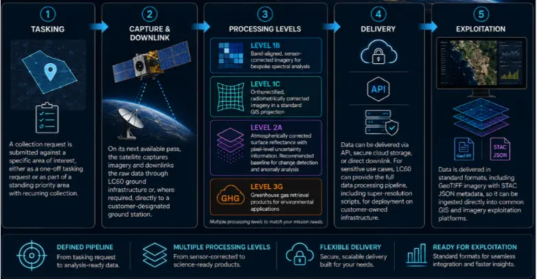
Capturing an image is only the first step. SWIRSAT data moves through a defined pipeline designed to turn raw sensor output into something an analyst or a system can actually use:
● Tasking. A collection request is submitted against a specific area of interest, either as a one-off tasking or as part of a standing priority area with recurring collection.
● Capture and downlink. The satellite collects imagery on its next available pass and downlinks the raw data, either through LC60’s ground infrastructure or, for customers who require it, direct downlink to a customer-designated ground station.
● Processing levels. Data is made available at several processing levels depending on the user’s needs. Level 1B provides band-aligned, sensor-corrected imagery for users conducting bespoke spectral analysis. Level 1C delivers orthorectified, radiometrically corrected imagery in a standard GIS projection, ready to drop into mapping software. Level 2A provides atmospherically corrected surface reflectance with pixel-level uncertainty information, which is the recommended baseline for change detection and anomaly analysis. Level 3G provides greenhouse gas retrieval products for environmental applications.
● Delivery. Depending on the customer, data can be delivered through an API, secure cloud storage, or direct downlink. For the most sensitive use cases, LC60 can provide the full data processing pipeline, including super-resolution scripts, for deployment on a customer’s own infrastructure, so the data and its processing never need to leave that environment.
● Exploitation. Data is delivered in standard formats (GeoTIFF imagery with STAC JSON metadata) so it can be ingested directly into common GIS and imagery exploitation platforms rather than requiring a proprietary viewer.
What Can SWIRSAT Be Used For?
Because SWIR reveals what optical imagery alone cannot, SWIRSAT supports a wide range of applications across both civil and government use cases.
● Maritime domain awareness. Coastal haze, sea mist, and humidity routinely degrade optical maritime surveillance, particularly at dawn and dusk. SWIRSAT maintains usable imaging performance through these conditions, supporting vessel detection, classification, and activity monitoring, including cases where vessels are attempting to avoid detection through conventional means.
● Counter-concealment. SWIRSAT’s sensitivity to material composition, rather than visual appearance, supports identification of camouflage netting, decoys, and structures built or arranged to resemble natural terrain. This strengthens confidence in target verification in situations where visual inspection alone would be inconclusive.
● Infrastructure and ground disturbance monitoring. Excavation, construction, and other ground disturbance activity leave distinct soil moisture signatures that persist well after the activity itself has stopped. SWIRSAT’s Band 2 sensitivity to soil moisture makes it well suited to flagging unrecorded excavation or unusual ground preparation for further investigation.
● Disaster and emergency response. SWIRSAT’s smoke-penetration band supports mapping of active fire perimeters and burn scars even when visible-spectrum imagery is fully obscured. Water’s distinct SWIR signature also makes flood extent mapping more reliable than relying on optical imagery alone, which can be complicated by cloud cover during major weather events.
● Resources and mining monitoring. The same material-discrimination properties long used in ground-based geological survey apply from orbit, supporting monitoring of activity at mining and resource extraction sites at a scale that would be impractical to survey manually on a recurring basis.
● Defense and government ISR. SWIRSAT supports infrastructure monitoring and post-event damage assessment where speed and confirmation through obscured conditions matter, functioning as a discrimination layer that adds confidence to what other sensors detect, rather than acting as the sole source of assessment.
Why SWIR Alone Isn’t the Whole Answer, and Why That’s the Point
SWIR is not designed to replace optical, radar, or thermal sensing, and SWIRSAT is not positioned that way either. Each sensor type has a role that the others cannot fully substitute:
● Optical imagery gives sharp, intuitive visual context that is easy to interpret at a glance, but it is blinded by cloud, haze, and smoke.
● Radar (SAR) penetrates cloud cover entirely and works day or night, but it struggles to distinguish between materials, since its return signal is driven mainly by surface geometry rather than composition.
● Thermal imaging detects heat regardless of light conditions, which makes it valuable at night, but it reveals nothing about material composition, only temperature.
● SWIR fills the gap between them: a confirmation and discrimination layer that resolves ambiguity when the other sensors reach the limits of what they can interpret.
On SWIRSAT, this positioning shows up directly in how the data is built, not just in how it is marketed. Every SWIR capture is co-registered with VNIR imagery, giving analysts one coherent dataset instead of two separate images to reconcile by eye. The goal is not to win a head-to-head comparison against any single sensor type, but to reduce the uncertainty that shows up when any one sensor, used alone, reaches the edge of what it can reliably tell you.
Frequently Asked Questions
No. Thermal imaging (MWIR or LWIR) detects heat that objects emit on their own, which is why it works in complete darkness. SWIR detects reflected sunlight, similar in principle to a regular camera, just at wavelengths beyond what the human eye can see. This means passive SWIR sensors, including SWIRSAT, depend on daylight to capture usable imagery.
Passive SWIR systems that rely on reflected sunlight, like SWIRSAT, cannot capture usable imagery at night. Some ground and airborne SWIR systems achieve night operation using an active illumination source, but that is a different mode of operation from daylight, sun-reflectance sensing.
No. SWIR is best understood as a complementary layer. Optical imagery provides intuitive visual detail, radar works through cloud cover in any light condition, and SWIR adds material and moisture-level insight that neither can provide on its own. Most serious ISR and Earth observation architectures use these sensor types together rather than relying on any single one.
Most consumer infrared, including basic night-vision equipment, operates in the near-infrared range, just beyond visible light. SWIR sits further along the spectrum, generally 1,000 to 2,500 nanometers, which requires different sensor materials and gives it stronger material-discrimination properties than near-infrared, though at a higher cost and complexity to build.
Resolution describes the smallest feature a sensor can distinguish, generally expressed as the size of a single pixel on the ground. SWIRSAT’s Super HD SWIR resolution of 4m means each pixel represents a 4-metre by 4-metre area on the ground. Objects smaller than that, or details within a larger object, will not be individually resolvable, though patterns across multiple pixels, such as a change in a facility’s layout, often remain clearly detectable.
SWIR resolution is coarser than VNIR resolution, since longer wavelengths generally require larger detector elements to achieve the same signal quality. Co-registering SWIR with SWIRSAT’s higher-resolution VNIR imagery means every capture includes both the fine structural detail VNIR provides and the material and moisture insight SWIR provides, in a single aligned dataset rather than two images that need to be manually compared.
Built for the missions that matter.
Five operational capabilities — each enabled by sovereign SWIR observation.

SWIR Intelligence for Missile-Related Damage Assessment
Post-event battle damage assessment for urban, industrial, and hardened-infrastructure environments — when smoke, dust, and debris saturate the air and every minute…
Read case study
Maritime Monitoring and Grey-Zone Activity Detection
Naval ISR for littoral, coastal, and congested sea lanes — closing detection gaps left by AIS-disabled vessels, persistent haze, and rapidly fading…
Read case study
SWIR Intelligence for Missile-Related Threat Assessment and Detection
Pre-event detection and post-strike assessment for urban, industrial, and hardened-infrastructure environments — where seconds matter and visibility is degraded.
Read case study
Discovery of Covert Ground Lines of Communication
SWIR-enabled ISR exposes concealed logistics routes, depots, and resupply movements that visible-spectrum imagery cannot resolve under canopy or terrain cover.
Read case study
Advanced Disaster Assessment via SWIR
Operational intelligence for disaster response in contested, obscured environments — SWIR enables continuity of collection when optical systems fail.
Read case study